
DOI: 10.18441/ibam.26.2026.92.113-133
Federico Navarrete Linares
Universidad Nacional Autónoma de México, México
fnl@unam.mx
ORCID iD: https://orcid.org/0000-0003-2766-7713
This article arose from the frustrating experiences I have had as a student and then academic who insists on walking around the sprawling, labyrinthine Ciudad Universitaria (CU) in Mexico City, the main campus of the Universidad Nacional Autónoma de México (UNAM). This is the place where I studied in the 1980s and have worked from the 1990s to this date. What I present here is an autoethnography (Méndez 2013), and, also an exercise in critical geography with a historical perspective.
Autoethnography allows me to explore my own intersectional position as a male, privileged, able bodied user of the public spaces of CU. I also compare it with the experiences of other users with different social conditions, gender identities and physical capabilities. Taking into account these intersectional differences in turn allows me to reflect on how rationally planned modern public spaces, such as the roads, buildings, and parking lots of the gleaming, high modernist campus of the UNAM, physically embed and entrench class, gender and physical discriminations, even when they do not take these dimensions into account.
Following Crenshaw I argue that these discriminations can be defined as structural intersectionality because they result from an original oversight, or deliberate decision, from the part of the planners regarding the class, gender and physical characteristics of their ideal users (Crenshaw 1991, 1245). I will strive to demonstrate that starting with its original planning in the mid 20th century CU was conceived according to strict functional and spatial segregations, which resulted in intended and unintended forms of exclusion and discrimination for many of its students, workers and visitors with different intersectional characteristics. I will also argue that these logics of exclusion and discrimination have been enforced and amplified in the physical expansion and modifications of the campus since then. The continuation of this forms of discrimination can be attributed to political and representational forms of intersectionality, also defined by Crenshaw (1992).
Ever since I enrolled in the University as a student in 1984 I have had a problematic relation with the spaces of CU because I have insisted in using them as a pedestrian. The campus was built atop an extensive lava field, known as El Pedregal, with a highly rugged topography, and it was designed mostly for automobiles. It was also organized according to strict principles of functional segregation, so that sports facilities are placed far away from faculties, and research and administrative buildings are located in remote areas.
Pedestrians moving around CU face many dangers, apart from the large distances and the topographical accidents in the terrain. Most roads have continuous turns and no traffic lights so there are few safe crossings, and many even lack sidewalks, which means that pedestrians are forced to walk on the roads alongside speeding cars. If they try to avoid the dangerous roads, they are often are forced to traverse jagged lava rock formations.
As a male student, and later as a male professor, I considered that being forced to trek, run and climb to get to my destination was a test of my physical fitness, even a sort of parkour. I also enjoyed observing the many things that happened in the sprawl-
ing campus, some of them illegal, and to explore its hidden gardens, and its inaccessible routes, like an adventurer.
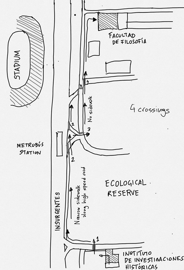
Sometimes, however, I regretted my own audacity. One time I tried to walk from my office building in the “City of Humanities” in the southern part of CU, to the Facultad de Filosofía y Letras in the opposite northern end of the campus. The route is less than 2 kilometers long but it runs along Avenida Insurgentes, a de facto high-speed road. For more than 1 km I was forced to walk along a crumbling narrow sidewalk between a wall protecting the huge ecological reserve at the heart of CU and the cars speeding by at up to 80km/h less than a meter away. Then I had to run across off-ramps, dodging the same cars as they veered from the main road to the university streets, never expecting a pedestrian. This led me to an even narrower pavement, like a tight rope between the busy street and a deep lava field with sharp edged rocks and apparently bottomless chasms. Of course, after this adventure I decided to never use that route again. This means that a walk that would take 20 minutes has to be substituted by a circuitous bus ride of 40 minutes or more.
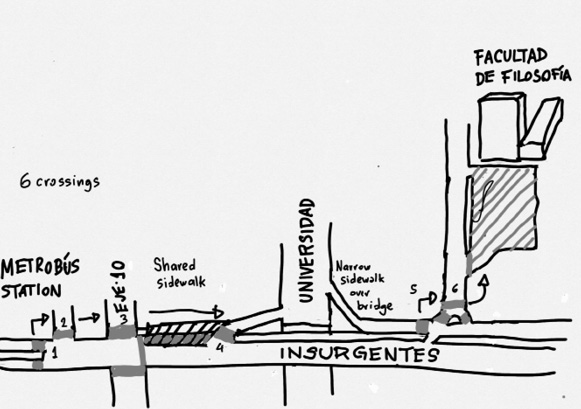
It is also hazardous to walk the 800 meters that separate the buildings of the Facultad de Filosofía y Letras from the nearest station of the Metrobús, the rapid bus transit system I use to go to work. Pedestrians have to cross several high traffic streets with insecure crossings. Most sidewalks are narrow and crowded, and for many years we had to walk a 100-meter stretch that was just 30cm wide, very close to the vehicles running down Insurgentes. During the rainy season, there were large puddles on the road and we were often drenched by the passing cars. Fortunately, now there is a pedestrian bridge, but that has been the only improvement to the route.
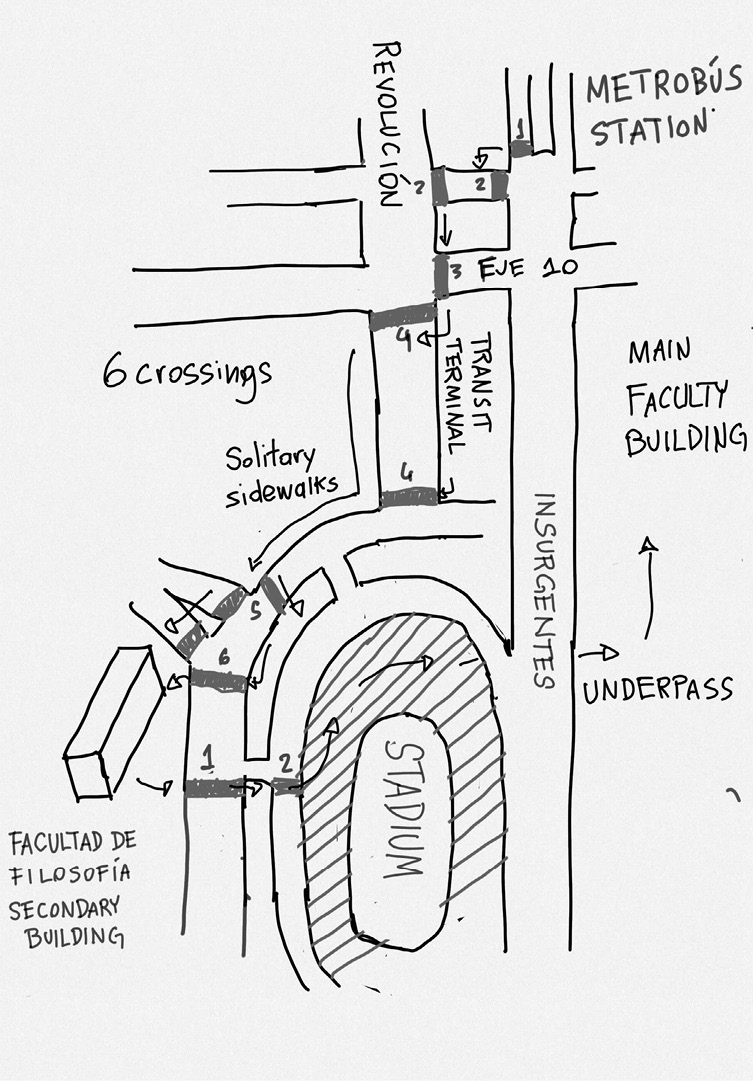
The route from the same Metrobús station to the secondary building of the Facultad, the Anexo Sánchez Vázquez, is even more perilous. These new facilities, meant to alleviate the dangerous crowding of the main building were erected in 2021, in the last available space in the northwest corner of CU, on the far side of the University stadium and the long circular roads that connect four busy urban thoroughfares. Pedestrians are forced to cross two high speed roads with no marked pedestrian crossings. Then they must walk down deserted and badly illuminated pavements, and later through a crowded private bus terminal, an urban space generally associated with sexual harassment and assaults.
For decades I was able to walk around this challenging environment because I was male, heterosexual and able bodied. Also, like many others in such privileged intersectional positions, I was not fully aware of the advantages they offered me. This is why, when my own daughter enrolled in the Facultad de Filosofía y Letras, in 2015, I was surprised to learn that she felt threatened by what I regarded as inconveniences. She was unsafe walking down the solitary sidewalks, crossing the unmarked roads, or traversing the public transit terminals. Through time, these pervasive dangers came to define a negative relation with the spaces of Ciudad Universitaria, and with the University as a whole.
At first, when she complained about these dangers, I tried to convince her that they were just the downside of attending a large public university. In doing so, I was simply parroting an argument that students and academics had long used to rationalize the glaring shortcomings of University spaces. And of course, it was more easily deployed by privileged male, able bodied and heterosexual male students and academics, like me.
For instance, we all knew that the bathrooms of the Facultad were filthy and decaying and learnt, or were forced, to put up with them. Of course, this was easier for men than for women, whose facilities were more even more dangerous. In a student strike in 1987, when we took control of University facilities under the banner of the Consejo Estudiantil Universitario, University Student Council, we tried to address this situation by making all bathrooms mixed-gender and taking scrupulous care of them. However, as soon as classes were resumed, the old gender divisions were reinstated, and the intersectional inequalities returned. Years later, the presence of male stalkers in the most remote female lavatories led the authorities of the Facultad de Filosofía to officially warn women against using them, thus reducing their access to sanitary facilities.
Similarly, we all have known for a long time that the remote corridors of the main building are often deserted and that the parking lots, roads and sidewalks around the main building of the Facultad are insecure. Even the locations where car-share services pick up students are physically distant, dark and dangerous. But all these dangers are far more acute for female and gender non-conforming students. Throughout the years I have heard many stories of harassment and assaults in these spaces, mostly told by women. In the past two decades they have become so perilous, that female students have to organize groups to walk to the Metrobús or metro station after dark.
This structural intersectionality, as defined by Crenshaw, has led my daughter, and many other female, Lgbttqi+ students, and physically challenged students to perceive and experience Ciudad Universitaria as unwelcoming and openly threatening to their wellbeing and security. While cis males share some of the dangers, their intersectional privileges shield them in many respects. Between 2017 and 2025, different student movements, mostly led by women, have protested against cases of violence and insecurity, and particularly against the sexual violence that thrives in the remote and unprotected areas of CU, as well as in its crowded school buildings. So intersectionality has become a political issue, as Crenshaw suggests. In the Facultad de Filosofía y Letras, a feminist group waged a months-long strike from 2019 to 2020, shuttering all academic activities as a protest against the indifference of University authorities to their plight.
Recently, as I have come out as a non-binary person, many of these spaces have become increasingly threatening for me, too. For instance, there has been a string of aggressions against non-binary people in the toilets of schools and research buildings (Aquino 2022). While university spaces are usually regarded as safe for people with non-conforming sexual identities, the roads and streets surrounding CU are dangerous for them, a problem exacerbated by the University’s longstanding refusal to build public transportation terminals inside its perimeter.
Similarly, the car-centric design of CU entrenches a class distinction between people with cars, and the vast majority of users who are pedestrians. But the disadvantages faced by the latter become more insurmountable for persons who are not male, or have mobility issues and physical disabilities.
The intersectional differences between the users of University spaces should also be understood in light of the contradictory relations between the intentions of the planners of these modern, rational, disciplinarian spaces, from the mid 20th century onwards, and the experiences, intentions and reactions of the students, academics and workers that move through them today, which are very different from those envisioned by the former.
Recognizing the intersectional differences between all these different users of University spaces, past and present, male and non-male, motorists and pedestrians, academics and students, physically able or with disabilities, has forced me to pose the central question of this article. How come this planned, spectacular and admired public space, which is supposed to be the pride of Mexico, and has been recognized as a World Heritage site by UNESCO since 2007, forces so many of its users to endure such inconveniences and hazards?
As Foucault shows in Surveil and Punish modern institutions like schools, factories, prisons and Universities work by building rationalized disciplinary spaces and facilities that are designed rationally to accomplish their specific goals: teach, produce, punish or educate. These spaces are built for some bodies and are made to exclude others. They were also organized to force these selected bodies to move, behave and perform the tasks that the planners intended, while simultaneously preventing them from doing things that they did not want them to (Foucault 1984).
The original planning of CU in the mid 20th century responded to a definition of the ideal University students as middle class, car driving, male, virtuous, obedient and ambitious individuals. It also sought to exclude different kinds of students, and particularly students as crowds, who were defined as rebellious lower class, dissolute, disorderly, and pedestrian (Miranda Pacheco 2017). Thus, University spaces were designed to protect and enable the former and to exclude and contain the latter.
From its conception Ciudad Universitaria was a space of power, a citadel. The protracted and expensive process of building the its main buildings between 1947 and 1954, turned it into a veritable monument of the Mexican revolutionary authoritarian regime. This was manifest in its huge scale and its spectacular architecture and modernist urbanism. The idea was that this gleaming campus would educate a new kind of student that would integrate a modern national elite, modeled after president Miguel Alemán, who was the first president who graduated from its Law School and who started the process of building CU (Mack 2019; Sánchez Michel 2014). These privileged individuals would study diligently, meet each other and share their ideas in safe and demarcated spaces, protected from harmful popular or subversive influence. In the original plan, the students were intended to live in the campus, provided with extensive sport facilities, and a catholic church to worship in (Sánchez Michel 2014). The inclusion of a religious temple inside the national university of the fiercely secular Mexican state reflected the conservative ethos of many of its members, and of the planners. However, a cost-cutting round in 1951 led to the scrapping of these facilities for students, except for the sports areas (Sánchez Michel 2014).
Following the modernist architectural ideals prevalent at the time, University spaces were organized according to strict principles of functional segregation, so that the different functions performed by students and workers would not interfere with each other. For instance, sports facilities were distant from the schools. Public transportation terminals were also placed far away to ward off CU from the networks of urban mobility, and from undesirable external crowds. While these long distances were daunting for pedestrians, they were far more convenient for automobiles, the preferred vehicle of the modern student.
Inside the faculty buildings, functional segregations also forced students and academics to separate their different activities and needs. To this day, they must walk down long corridors to find their classrooms, and use sanitary facilities that are distant and insufficient. Similarly, they must eat in distant, crowded and inconvenient places.
The main area of CU, built before 1954, erected all faculties and schools around a vast quadrangular esplanade meant only for pedestrians, which was bounded on the west side by the Rectory building and the overpasses of Avenida Insurgentes. The spectacular layout of central space was partially inspired by the citadels of Precolumbian cities, such as Monte Albán, and also by the central quads of the campi of American universities. The faculty buildings were, in turn, surrounded by the “School Circuit”, a circular road with continuous turns, very narrow sidewalks and just a few unmarked pedestrian crossings. The desired effect of this encircling route was to isolate the campus and its pedestrian spaces from the rest of CU and from Mexico City itself.
The intent of the planners was to facilitate the interactions between students from different faculties, creating a true “university spirit”. In the early 1950s, the philosopher José Gaos expressed the hope that this would enable a true dialogue between the humanities and the sciences, creating “the possibility of giving university life a sense of effective community or ‘city’” (Mack 2019, 229-232). Very soon however, many of access points between the different faculties were closed, as they became flashing points for political conflicts among the students of different political affiliations. Also, as the new faculties, such as Economics, or Political Sciences created physical demarcations to materialize their separation from the Faculty of Law (Mack 2019). This was a clear indication that the utopian ideals of the planners were being superseded by the realities of University life. Just two years after it was inaugurated, CU exceeded its planned capacity of 25,000 students. In 2024 it was used by close to 100,000.
From the point of view of the planners and politicians in the mid 20th century, the planning of CU as a city for motorists was the confirmation of the avant-garde nature of its urbanism, as well as the modernity of Mexico City and the whole country (Mack 2019; Sánchez Michel 2014; Krieger 2014). The regime of the time had adopted a development policy centered on the creation of a local auto industry and the building of roads and highways all over the country. Even the communist muralist David Alfaro Siqueiros, decorated the Rectory building of CU with wall paintings that were designed to be admired from cars speeding along Avenida Insurgentes. Both the conservative planners and the revolutionary artist fetishized machines and speed as harbingers and symbols of progress. In a decidedly less aesthetic manifestation of this hegemonic conception, all University buildings were provided with large open air parking lots, which became their main access routes, and remain so to this date.
As part of its paradigm, CU was designed to be linked to the developing road network of Mexico City. It was traversed by Avenida Insurgentes the main north-south thoroughfare joining all the richer parts of the town. In the following decades, it was further integrated into the growing network of freeways and roads serving the expanding town. Since the 1980s it has also been linked to the slower growing networks of public transportation with two Metro stations to its north and east and 3 Metrobús stops along Avenida Insurgentes.
As the same time as the planners of Ciudad Universitaria have done everything to facilitate circulation by cars, they have excluded public transportation. The original plan of CU included a terminal inside its premises. Following the segregationist logic, it was placed at a distant end of the campus, behind the Sports Stadium, far away from the convenient parking lots reserved for car drivers. Even so, it was scrapped in the building phase and has never been contemplated again. For a time, a small bus terminal operated adjacent to the Rectoría building, but it has since been turned into a parking lot.
The Metro stations of Copilco, to the North, and Universidad, to the East of CU, were built in 1984 and they were placed outside the borders of CU, and rather distant from its core area. No provisions were made for the pedestrians accessing the University from the first station. For many years they had to enter through the tiny pedestrian doors in the northern wall (Krieger 2014) and risk crossing the jammed Circuito Escolar without secure pathways. The better planned entrance for Metro CU, lay more than 1 km away from most of the schools. It took two decades for the internal Pumabus network to join them in a relatively reliable way with the faculties.
The exclusion was also enforced when the city government in 2005 built the first line of the Metrobús alongside Avenida Insurgentes, traversing CU. Mindful of the impending declaration of the central campus as a world heritage site, the University authorities prevented the construction of a station in front of Rectoria, and the large central esplanade providing convenient and secure access to the schools and faculties. The authorities expressed the concern that building a Metrobús station in that convenient location would only increase the opportunity for students to engage in sit-ins and protests, and to vandalize university property.
Instead, they built a central station for the whole of CU more than 1 km away from the school buildings. The idea was that users would alight there and then board internal buses to reach their specific destinations. This added significant time and inconvenience to the journeys of most students, which were already quite long. According to a mobility survey carried out by the University (UNAM 2014), the average travel time required by students to arrive to the CU campus from their homes was 1 hour and 45 minutes, with a significant portion requiring between 2 and 3 hours. The remote location of the Metrobús station added a further 15 to 30 minutes of travel time to their faculties. In contemporary Mexico City one of the main indices of inequality is the time used in daily commuting so that this planning decision affected precisely those students and workers that were already at a disadvantage. Remarkably, but not surprisingly, not a single new walkway was built to facilitate pedestrian traffic between this station and the main schools.
The central Metrobus station was also located too far away from the highly attended Centro Cultural Universitario to the south of CU and site to its most important cultural venues. There was also no action to build a walkway or direct route between these points, since it would have to cross the ecological reserve. During weekends there was also no bus service to bridge the distance, so that all the cinemas, theaters, museums and concert halls became inaccessible to pedestrians. Meanwhile, in true CU style, car owners could drive to the huge parking lots that also served as the only access points to the facilities. This problem was only solved years later when student pressure led to the opening of a new Metrobus station near the Centro Cultural Universitario.
After decades, the public transportation of the campus was finally organized into an exhaustive network, called Pumabús. However, as we shall see the rugosidade of CU makes the bus routes too indirect and lengthy, increasing transportation times. Moreover, the buses have limited schedules and are less available at night, precisely when the dangers of walking down dark and deserted roads become more acute.
I have described the dangers and inconveniences faced by persons who must or prefer to come by foot and have to deal daily with the results of these planning decisions.
The successive waves of physical expansion of university spaces in CU, from the 1970s to the 2000s, have maintained and even strengthened the functional and social segregations established by the original planning. After the 1968 student movement, which led to a months-long occupation of its facilities first by the protesting students and then by the army, the University embarked on a significant expansion of its student and academic body, as well as of its physical infrastructure. This led to the outward migration of some faculties, and most of the research institutes and cultural venues to the south and east of the vast terrain allocated to CU but not developed in the 1950s. The distances to these new facilities were long, and there were almost no proper access routes for pedestrians. This meant that the researchers, their libraries, their laboratories and other key University resources became almost inaccessible to the majority of users, particularly the expanded student body.
The expansions of the 1970s and 1980s followed the original planning conceptions of CU. The new buildings were erected alongside the circular roads designed by the original master plan of the city, and also along new circuits that extended this car-friendly but pedestrian-averse design. There were no radial roads to reduce the distances. As in the 1940s and 1950s, planners sought to isolate valued university spaces from outsiders. Only this time they sought to keep at bay a growing student body which conformed less and less to their original middle-class ideals and was regarded as politically threatening. It can be argued that these expansions modified the social function of the original car-centric urbanism. In the 1940s the long roads were conceived as a promise of future high-speed mobility for (nearly) all, as celebrated by the murals of Siqueiros. Three decades later, they became an expression of social and institutional privilege, entrenching the marginalization of pedestrians and of most students.
The new research and administrative buildings were embedded, far more than the previous buildings in the Central campus, into the rugged ravines and plateaus of the Pedregal. This aesthetic choice made them even more inaccessible, making necessary the use of stairs for many walkways. Even more markedly than in the older development of CU, the only convenient and direct access routes to most of the new buildings was through their huge open air parking lots. Significantly these isolated sites were called the “City of Sciences” and later the “City of Humanities”, defined as isolated citadels inside the already isolated Ciudad Universitaria.
After seven decades, the logics of the original spatial organization of CU, with its combination of inclusions and exclusions remain determining. In 2020, a fellow researcher from my own institute at UNAM agitated for the construction of a safe walkway between the Ciudad de las Humanidades and the Centro Cultural Metrobús station at Insurgentes. This route is less than one kilometer long, but it can be dangerous, particularly after dark and particularly for women. As she related me, University authorities patiently explained to her some of the insurmountable obstacles for any improvement. For starters, there was no space for new construction due to the ecological and heritage constraints in the area. Also, the fences that interrupted the existing route and which were frequently locked, cutting off access and forcing pedestrians to make their way through the jagged rocks of the Pedregal, were under the control of unionized employees who could not be forced to stay after hours to keep them open. As my colleague asserted her right to safely move around CU as a pedestrian, the officials asked her to confirm if she was indeed a full-time academic. When she assented, they inquired, with a mixture of incredulity and exasperation: “Then why don’t you get a car?”.
A director of one of the research institutes related to me that around 2015, a group of architects proposed a new design for the spaces around Avenida Insurgentes in the southern end of CU, providing bike routes and walkways for pedestrians and restricting some automobile traffic. The plan was summarily squelched by University officials who complained that it would force them to spend more time in their cars in order to get to the parking lots in front of their offices.
Crenshaw’s concept of structural intersectionality allows us to understand how the generalized discrimination against pedestrians built into University spaces, based mostly on class considerations, affects those with other intersectional identities more acutely, particularly women and persons with physical disabilities. The concept of political intersectionality, in turn, explains why the powerful protest movements initiated by women in the past decade have succeeded in addressing and counteracting some forms of gender discrimination and violence, but have not been as successful in addressing and combating the other forms of discrimination, based on class and mobility, produced by the spatial configuration of CU.
To better way to understand how this spatial organization affects its users, we can also resort to Sara Ahmed’s phenomenological descriptions of the physical dimensions of racial and gender discrimination (Ahmed 2007). Whiteness, maleness and upper-class belonging are experienced by certain persons as affordances that allow them to occupy and move through social spaces with a greater ease. This happens because these spaces have been designed for accommodating these kinds of persons and also excluding, or challenging, other kinds. For some, there are parking lots, doors and pathways, for others long sidewalks and dangers.
Thanks to the urban design of CU, a tiny minority of academics, and some students, can drive their cars and park in front of all the buildings. These conditions also grant them easier access to all services provided by the Universities, from libraries and laboratories to comfortable and expensive places to eat.
Male pedestrians with no mobility problems can walk to them in relative security but with effort, and may even regard the exclusionary organization of the space as a challenge to surmount, as happened with me. But they all have to cross or go around the huge parking lot filled by the motorists. Of course, if some of them have a darker skin color or wear inadequate clothes, or do not conform to gender norms, their presence in those spaces can be questioned or they can be expelled from them, as has happened to several trans women using the women’s bathrooms.
Worse still, these spaces, and their affordances for learning, researching and even eating, are difficult to reach and use or even inaccessible to persons of other genders or different physical abilities. Most woman feel afraid to stay in the library after dark, but the ones with automobiles are less exposed as their classmate without such vehicles.
University spaces, as most disciplinary institutional facilities, were planned to provide affordances to some, allowing them to accomplish goals, perform roles, achieve success, and also create obstacles to others, because they were of the wrong class, gender, aspect.
We can agree that the most widespread and defining inequality in the spaces of Ciudad Universitaria are the advantages and services afforded to car drivers, mostly workers and functionaries at the expense of 90% of the University students, and perhaps most of its workers, who do not come to CU by car, according to a mobility poll made by UNAM in 2014 (UNAM 2014). This discrimination was intended by the planners, and has been maintained and enforced for seven decades. Intersectionality allows us to identify how pedestrians are affected in different ways by the exclusionary logic, according to their other identities or identifications. As Crenshaw demonstrates, by not thinking about the ways in which their urbanistic decisions would differently affect women, or persons with mobility issues, they ended up discriminating and excluding them.
The rationally planned spaces of Ciudad Universitaria are part of larger, previous and adjacent social spaces, that of the Pedregal de San Ángel lava field, and that of Ciudad de México.
We should understand the complex relation between CU and its “environment” not simply as an adaptation to the landscape, but as the actual building of that landscape as part of the logics of capitalist urbanization. To understand this construction of the Pedregal and of CU we can use the concept of rugosidade, coarseness. Milton Santos used this Portuguese word to explain how particular places, with specific configurations of relations built through time, offered different amounts of resistance to the rational organization of space, according to a capitalist logic (Santos 2000). He showed how places with certain rugosidade were better able to resist the imposition of the exploitative logics of this world system as they were embedded in their space. In my analysis I would like to expand the meaning of rugosidade and to give it a twist, following Santos’s own concept of the interaction between nature and culture in space.
This will serve to understand the specific form in which modern urbanism and the logics of capitalist land development embedded themselves and transformed the rugged lava field of El Pedregal to the SW of the growing Mexico City into a site for two different and opposed logics of urban development, as well as a landscape domesticated into ecological zones and gardens. This massive field of 50km2 dates to 2000 years ago and was produced by one or several eruptions along the volcanic ridge that traverses the Valley of Mexico. Its spectacular rugged landscape, a peculiar combination of massive irregular lava rocks and crevices and a lush vegetation and abundant animal life, was the inspiration of several contemporary artists, such as Diego Rivera and Dr. Atl, and the photographer Carlos Salas Portugal (Krieger 2021; Sánchez Michel 2014). These artists constructed an image of it as a sort of primeval wild Mexican landscape, associated with the Pre-Columbian past. It was also regarded as a refuge for transient and marginal populations who hid in its labyrinthine nooks (Eggener 2001).
This imagined wilderness was at the front line of the southward expansion of the privileged sections of Mexico City along the western and southwestern end of the Valley which was more temperate and fertile. As Sergio Miranda has argued, this was part of a growing inequality in the growth of modern industrial Mexico City, which privileged the development of richer and better planned neighborhoods and suburbs along that axis. At the same time, it devoted less resources to the development of the poorer more densely populated eastern suburbs of the city, and to the industrial north (Miranda Pacheco 2017).
Rugosidade allows to see that the rugged lava field not simply a “natural” constraint upon human construction but also as part of spatial relations between planners, motorists, pedestrians, rocks, roads, institutions. Architects, urbanists and developers envisioned El Pedregal as an empty wilderness, but it was actually a marginal rural area, belonging to the traditional towns of San Jerónimo to the southwest, Padierna to the souht, Copilco to the north and Santo Domingo to the east. They planted, foraged, hunted and performed other activities in its rugged terrain.
In the mid 20th century, this space became the site for two different forms of urban development. One of them is visible in CU and the neighboring Jardines del Pedregal, and follows the logic of modern capitalist urbanism, aimed at creating a “beautiful”, privileged and profitable suburban landscape. The other is evident in the spaces of Pedregal occupied by spontaneous low-class urban development, based on collective organization to occupy and obtain land plots. The first is an elitist urban development with a conjunction of picturesque garden landscapes and “pristine” ecological reserves, and a constant quest for seclusion. The second a highly dense, rugged self-constructed urban landscape (Krieger 2019). These forms of constructing space have confronted each other and have increasingly been separated by hard spatial and jurisdictional borders, creating a highly exclusionary division of space, a tense border which we shall examine later on.
The roots of the elitist urbanization are found in the early 1940s. The prominent Mexican architect Luis Barragán bought the vast landholdings of the hacienda of El Parián, in the northwestern end of the lava field, and designed a new extensive suburb for the richest elites of the city, Jardines del Pedregal (Eggener 2001). In 1942, the famous muralist Diego Rivera started building the Anahuacalli, an artist studio, museum and personal mausoleum, on the eastern edge of the lava field, on the other side of the town of Santo Domingo. In 1945 the government authorities expropriated the lands in the central part of the Pedregal for the new Ciudad Universitaria (Sánchez Michel 2014).
These urbanistic and architectural projects shared similar aesthetic premises. They were summarized by Rivera in a article titled “Requisitos para la organización del Pedregal” (Rivera 1949). In order to preserve the pristine beauty of the lava field, development would have to be as low density as possible, allocating large land plots and building only in a small fraction of them. For both aesthetic and practical reasons Rivera proposed that only the top layer of the lava should be carved out, and all roads and buildings should adapt to the elongated curvaceous forms of the deeper depositions.
In Jardines del Pedregal this led to the building of curvilinear roads with plots of 1,000m2 or more for single family units. The spectacular “primeval” landscape was turned into truly strking private gardens that contrasted with the modern functionalist architecture of the houses, creating a typically Mexican modernism. This very successful high value land development project has been hailed as an authentic and picturesque Mexican adaptation of the modern suburban form, including its strict functional segregations.
The original design of Ciudad Universitaria followed the same aesthetic and social definitions and so it was conceived as a suburb. Its extensive layout contrasted with earlier proposals for the university city from the 1930s and 1940s which had dense networks of roads and squares and juxtaposed spaces with mixed functions (Sánchez Michel 2014). The suburban ideal was also a local adaptation of the bucolic campi of American universities, whose splendid isolation contrasted with the bustling and noisy city centers.
It was this aesthetic and profitable rugosidade that led the planners to build long concentric semi-circular roads, with no radial thoroughfares, adopting the Herrey system of continuous turns and constant circulation for roads (Krieger 2004). This greatly increased the distances that had to be covered to get from one part of the campus to the other. Originally, cars and pedestrians were also meant to be separated, so that they would not interfere with each other. This meant that there were no sidewalks alongside the long winding roads, further hampering pedestrians. This elitist urban planning may have many ecological advantages but it has created in turn a daunting physical and intersectional rugosidade for most of its users, making access a lot harder and hazardous.
The segregationist and exclusionary logics of the elitist developments of El Pedregal succeeded in transforming its rugosidade into a scarce and unique space, with extraordinary capital value, both monetary and symbolic. The singularity of this particular relation between capitalist spatial logics and other social and natural spatial forms, as well as the topography of the lava field, gives it extraordinary value as an authentic and unique space, following the logic outlined by Harvey in his article on the art of the rent (2001). The result is the high land value reached by the residential development and the exceptional cultural, architectural and ecological prestige accorded to CU, which has been exploited by the University in many ways.
In 1993, the University authorities established an ecological reserve in a significant swath of Pedregal in the center, west and south of CU (Krieger 2021). This was defined as the last “pristine” corner of the unique ecosystem of El Pedregal, salvaged from the elitist developments of the 1940s and the informal settlement of the area of Santo Domingo from the 1960s onwards. The establishment of the reserve between the already existing circular roads has precluded any modification of the original car-centric design of CU. Also, in 2007 the central area of CU was officially declared a world heritage site by UNESCO. This confirmation of its extraordinary aesthetic quality also eternized its original design.
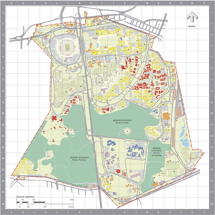
Examining the official map of Ciudad Universitaria allows us to envision the specific spatial configuration resulting from the articulation of this particular combination of value, topography, and rational planning. It is produced by the Dirección General de Obras, the office in charge of all architectural projects in the university. Since the functional segregation of space has always been a central tenet of the planning of CU, the map is able to define every single place within its territory according to a strict functional color code. And this, in turn, allows us to carry out an exercise in pixel counting by color, in order to compare, in relative terms, the spaces devoted to each function.
For starters, 30% of the total area is devoted to the ecological reserve established in 1993. A further 38% is marked as areas that have not been built upon, and we can assume that it consists mostly of lava fields and gardens. This means that according to this particular articulation between planning, capitalist logics of development, and the materiality of the rocky landscape, only 32% of the total area can actually be built upon.
Also by design, this scarce space is organized in highly unequal ways. Roads constitute 12% of the total area of CU, and parking lots 8%. The remaining third of the third (a mere 12% of the total area), is devoted to all the facilities that allow CU to operate. Sport areas occupy 3% of the total area, and all buildings the remaining 8%. Thus, more than 100,000 users of university spaces are crammed into the same horizontal area devoted to open air parking lots for 10,000 cars at most. Of course, most buildings have several floors so the actual space occupied by humans is actually larger, but it remains a small fraction of the total area of CU, and smaller than the area devoted to cars.
The total built area is also allocated unequally. Only about a third, that is 3% of the total area, is devoted to schools and faculties occupied by the vast majority of users. Assuming that all these teaching facilities have three floors, that would lead to an approximate total area of 9% used by more than 90% of users, just equivalent to that devoted to the cars used by a small minority of the users.
The remaining two thirds, 5% of the total area, are devoted to administrative and research buildings, and to cultural venues, and are used by much less workers and students. They all have their huge parking lots.
The inequalities generated by the planning rationality and the rugosidade of El Pedregal are amplified by the ambiguous but deeply entrenched link between University autonomy and territorial control. In the mid 20th century, the building of an independent, distant and self-contained campus that would concentrate most of the activities of UNAM came to be regarded as the confirmation of the institution’s right of self-determination, manifested in its autonomy granted by the government in 1929 (Miranda Pacheco 2017; Sánchez Michel 2014; Mack 2019). The physical remoteness of the Pedregal site, and the barriers erected around it were meant to protect the University, and its students and academics, from outside influences and from government interference. To this date, ordinarily CU lies outside the direct jurisdiction of the security forces of the Mexican state and of the Mexico City government, and the police is excluded from its spaces. Thus, the University treats its physical limits as a kind of jurisdictional border, inside of which it controls security. In order to protect it, its authorities have erected walls and gateways. Just like international borders, the limits of CU are designed as filters and operated to be at the same time entryways for some and unsurmountable walls to others (Picozza 2022). Also, as happens around many borders, the adjacent areas have become a sort of no-man’s land beyond the purview and responsibility of University authorities and of the city government.
In its northern and eastern borders, CU is adjacent to the unplanned spaces of El Pedregal in the traditional pueblos of Copilco and of Santo Domingo and in the extensive lower and middle-class neighborhoods that have grown beyond them. The contrast and incompatibility between these two distinct modes of urbanization was evident in the treatment accorded by the University planners to the families whose lands were expropriated in favor the University, mostly neighbors from the town of Copilco. In compensation for the loss of their homes, the University built 60 housing units for them, benefiting just a fraction of the families involved. These were placed outside the perimeter of the new university, to the northeast, close to the community of Copilco el Alto. The single room, 35m2 family units were poorly built, with only 4 bathrooms for all of them. The architects argued that the inhabitants were used to living in hovels and would be suffer from a violent “accommodation process” if they were provided with better housing (Mack 2019, 128-130).
Thus, the northern and eastern limits of CU have become a strictly demarcated class border, guarded by a long stone wall, built with the rocks taken from the lava field. There are to this date only a half dozen narrow metal doors along it, and the distant entrance to the Ciudad Universitaria Metro station. For the first half century of University life, the pedestrians who entered through them were not provided with safe crossways or even proper sidewalks. These are precisely the entrances that 90% of University users who arrive through public transportation are forced to use by the exclusion of proper stations inside CU. Not surprisingly, this exclusion has been justified by the need to protect the territory of CU from dangerous actors who would threaten its autonomy, coming from the nearby towns or barrios, or from all the city through the public transport networks.
From outside, these doors, were only accessible from back allies and from what appeared to be vacant lots. With time they have been occupied by street vendors, providing services that were unavailable inside the University. At best, they looked and felt as entrances for “service personnel”. At worst they seemed a mere afterthought in the general planning, placed haphazardly with no regard for the safety or well-being of pedestrians.
In contrast to this hard urban, social and jurisdictional border, the south and west limits of CU are open, and consist mostly of a network of high-speed roads, giving convenient access to the middle and upper class “colonias” and “fraccionamientos” near the university, such as El Pedregal, and most importantly to the growing highway system of Mexico City. Like the heart of a circulatory system, the convoluted viaducts of CU join the arteries of five high traffic avenues, integrating the road network for southwest area of the town. Although there are barriers that close off some of the roads on the weekends and during school vacations, the rest of the time they are left open for the convenience of motorists escaping the clogged roads and, also of university car owners. In these spaces, the desire to surveil and restrict access to foreign elements, as well as the safety of pedestrians, are subordinated to the imperative of letting cars speed through.
Paradoxically, the layout of CU has so successfully promoted the use of cars that it now has run out of space for them. Despite the fact that a full two thirds of the limited area open for development is devoted to cars, traffic congestion has become a problem in the main university circuits. Also, the staggering 8% of the total area of CU dedicated to open air lots has become clearly insufficient. The original car-centered utopia that any and all users of University facilities could drive in and park conveniently right at the entrance of the buildings has been substituted by a tightly regulated parking apartheid. Most of the large lots placed at the front of buildings are now restricted to academics and functionaries. Students and visitors are supposed to park around the main stadium, often more than 1 km away from their schools and faculties. This means that as much horizontal space is reserved to an increasingly small minority of the population (far less than the 10% who use cars), as is allocated to all the buildings occupied by all the users of CU.
The southern and western end of CU are also characterized by the enforced voidness of the ecological reserve. To preserve the integrity of the reserve and to prevent illegal acts in its vast empty spaces, authorities have been forced to build fences around them, enclosing them on all sides. These barriers transform the wilderness of the Pedregal into a kind of garden, not unlike those that adorn the luxury houses of Jardines del Pedregal. In this way, 80 years after Rivera first defined the terms for the development of the Pedregal, the transformation of an open wild landscape into a closed garden has come full circle, in the name of saving the ecosystem destroyed by development.
As we have seen, the urban design and the spatial configurations of CU are riven with contradictions and intersectional inequalities. The main university campus cannot be defined entirely as a public space, because many of its buildings are closed off to the public and are also almost inaccessible to people without cars. And yet, CU is an important thoroughfare communicating the main avenues of the southern part of the city.
It is a public space because the University itself is public, and supposedly open to any student with the adequate qualifications, and yet its car-centered urban design hinders, inconveniences and even endangers, the vast majority of its own students and workers. While this inequality is shared with most other modern urban spaces, the rugosidade of CU makes it particularly daunting.
This same rugosidade, the result of the interaction between the rugged lava field and an elitist form of capitalist land development, has provided the architecture and planning of CU with an exceptional value in symbolic terms. This symbolic value has been promoted constantly and quite successfully by the university. The more entrenched and recognized it has become, the more it has squeezed most of its users quite literally between a rock and a hard place, that is, between the huge lava fields of the ecological reserve and the long winding roads designed exclusively for cars. The environmentalist commitment to preserving the original landscape of the Pedregal is belied by the fact that 12% of the University space is dedicated to roads, and 8% to open air parking lots, an inefficient and anti-ecological use of the scarce land that the same model allows to be developed.
From its original planning, CU was designed to be an exclusionary space, favoring some kind of students over others and it has deepened this segregationist logic in its subsequent development over 7 decades. Originally, the car-centered urban design of CU was predicated on an optimist modernist vision of the future of the University and its student body, as part of an expanding middle class in Mexico. However, from the 1970s it has become more of a tool for enforcing social segregation and distinctions.
The result has been a systematic disregard for the safety and well-being of the majority of the University population, affecting particularly the groups already exposed to more discrimination in Mexican society, such as lower-class students, women and people with mobility issues. The resulting intersectional inequalities, exclusions and dangers have been addressed only recently and the measures have been only partial, since the original planning and its segregationist logic has become irreversibly embedded in the rugged landscape.
Ahmed, Sara. 2007. “A Phenomenology of Whiteness.” Feminist Theory 8, no. 2: 149-168.
Aquino, Eréndira. 2022. “Estudiantes trans de Filosofía y Letras de la UNAM denuncian mensajes de odio; exigen seguridad.” Yahoo Noticias. https://es-us.noticias.yahoo.com/estudiantes-trans-filosofía-letras-unam-114016032.html.
Crenshaw, Kimberlé. 1991. “Mapping the Margins: Intersectionality, Identity Politics, and Violence against Women of Color.” Stanford Law Review 43, no. 6: 1241-1299.
Eggener, Keith. 2001. Luis Barragan’s Gardens of Pedregal. Princeton Architectural Press.
Foucault, Michel. 1984. Vigilar y castigar. Nacimiento de la prisión. Traducción de Aurelio Garzón. Siglo XXI.
Harvey, David. 2001. “The Art of Rent: Globalization and the Commodification of Culture.” In Spaces of Capital: Towards a Critical Geography. Routledge.
Krieger, Peter. 2004. “Hermann Zweigenthal-Hermann Herrey: Memoria y actualidad de un arquitecto austriaco-alemán exiliado.” Anales del Instituto de Investigaciones Estéticas 26, no. 85: 7-30.
— 2014. “La Ciudad Universitaria al límite: implosión y explosión de un patrimonio sobresaliente en la megalópolis.” In Habitar Ciudad Universitaria 60 años. 1954-2014, edited by Salvador Lizzárraga Sánchez y Cristina López Uribe. Universidad Nacional Autónoma de México, Facultad de Arquitectura.
— 2021. “La Reserva Ecológica del Pedregal de San Ángel (REPSA).” In Guía del Patrimonio Científico y Tecnológico de la CDMX. https://patrimonio-cyt-cdmx.colmex.mx/reserva-ecologica-del-pedregal-de-san-angel-repsa/.
Mack, Jessica R. 2019. “A Campus for Mexico: Knowledge and Power in UNAM’s University City.” PhD dissertation, Princeton University.
Méndez, Marisa. 2013.“Autoethnography as a Research Method: Advantages, Limitations and Criticisms.” Colombian Applied Linguistics Journal 15, no. 2: 279-287.
Miranda Pacheco, Sergio. 2016. “Por mi raza hablará la metrópoli: Universidad, ciudad, urbanismo y poder en la construcción de Ciudad Universitaria, 1929-1952.” In El historiador frente a la ciudad de México, edited by Sergio Miranda. Universidad Nacional Autónoma de México, Instituto de Investigaciones Históricas.
Picozza, Fiorenza. 2022. “Huida, cimarronaje y santuario: Genealogías críticas para des-eurocentrar la historia del refugio en el Atlántico Negro.” Scripta Nova 26, no. 2: 101-124.
Rivera, Diego. 1949. “Requisitos para la organización del Pedregal”. Novedades, Suplemento México en la cultura, 3 de julio: 22.
Sánchez Michel, Valeria. 2014. “Construcción de una utopía: Ciudad Universitaria, 1928-1952”. PhD dissertation, El Colegio de México.
Santos, Milton. 2000. La naturaleza del espacio: Técnica y tiempo, razón y emoción. Alianza.
Universidad Nacional Autónoma de México (UNAM). 2014. “Encuesta de movilidad UNAM: Resultados preliminares”. https://urbanismo.posgrado.unam.mx/Doc/semestre%202020-2/Encuesta%20de%20Movilidad%20UNAM_Resultados%20preliminares.pdf.
Manuscript received: 28.03.2025
Revised manuscript: 27.11.2025
Manuscript accepted: 16.03.2026